RSS

Monthly Archives: January 2011

Minato Chausuyama Kofun – No central personage interred inside?

Minato Chausuyama Kofun (湊茶臼山古墳), located in Minato, Okayama city, Okayama prefecture, is a zenpōkōenfun measuring approximately 130 meters in total length. While, on the whole, it is fairly flat and low-sitting for a keyhole-shaped tomb, the extremities of its kōenbu (the rounded rear) and zenpōbu (the rectangular front) rise markedly. The land now covered by paddy fields that stretches southward of the tomb was submerged under the ocean during the early 5th century, when it is believed to have been built (refer to the map under the “Map” tab to see the proximity to the Inland Sea).

Minato Chausuyama Kofun apparently has no elaborate stone-chamber burial facility nor central personage buried within. While a large pit (攪乱坑) measuring approximately 3.5 meters in diameter and over 3.5 meters deep was discovered in the center of the kōenbu, it is suspected to be evidence of looting (see this video for a visual of the pit). This is not to say that Minato Chausuyama Kofun is simply a pile of dirt, however; it still functions as a grave: Running parallel to the tomb’s central axis are two secondary burial facilities. Their small size for a kofun measuring over 100 meters and their position off from the kōenbu‘s nucleus strongly suggest to archaeologists that they are the resting places of inferior retainers or family members of the individual supposed to be interred within. Burial Facility 1 measures 4.5m long and 2m wide, and is a simple clay-covered waridakegata mokkan (割竹形木棺; a split-log wooden coffin). Burial Facility 2 measures 7m long and 2m wide, and is an example of a nendokaku (粘土槨), a clay-encased waridakegata mokkan. Neither of these would qualify as the burial facility of a personage requiring an approximately-130-meter-long keyhole tomb. Researchers can only speculate as to why this large-scale tomb does not contain a central burial — and most suggest that (for some reason or another) it is incomplete. This possibility is bolstered by the absence of fukiishi (葺石; paving stones) and the limited number of haniwa figures.

Haniwa are believed to have once lined the kōenbu, but they have found their way into the large, open pit. They appear in two varieties: House-shaped figures (iegata haniwa 家形埴輪) and a partial suit of clay armor. The house is of irimoya (入母屋; hip-and-gable) construction and displays a wickerwork (ajiro 網代) design on its roof. Across its ridgepole is laid a katsuogi (勝魚木, 堅魚木, 鰹木, in addition to many other variations), evidence of its early inclusion into the arsenal of ritual architecture. References in the Kojiki lead one to believe that it was originally reserved solely for members of the imperial family, but soon expanded to other Shinto-related, influential families (the JAANUS page mentions the Nakatomi and Mononobe families).

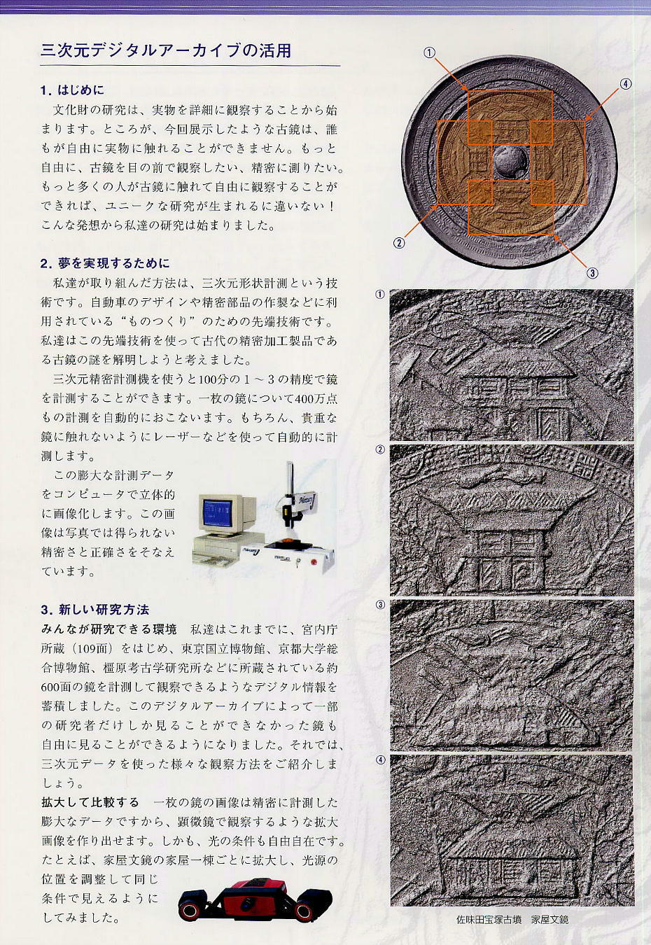
Another ancient example of irimoya construction, which is seen quite frequently later in Buddhist-temple and Shinto-shrine architecture, is found on a mirror unearthed from Samitatakarazuka Kofun (佐味田宝塚古墳), a late-4th/early-5th century zenpōkōenfun found in the Umami Kofun Group (馬見古墳群; the same kofun group that includes Suyama Kofun, discussed below).

(picture source; see picture source and this link for additional pictures and analysis)

Surrounding the central knob (chū) are four different designs of Kofun-period houses, and included therein is a house displaying irimoya construction.

Returning to the haniwa recovered at Minato Chausuyama Kofun, all that is extant of the clay suit of armor (if it ever was a complete set connected to a cuirass [tankō 短甲]) is a kusazuri (草摺; skirt of armor worn to protect the lower torso and upper thighs) replica, which bears an ayasugimon (綾杉紋; herringbone design) design, mimicking fastened plates of iron armor.

Structurally of interest concerning Minato Chausuyama Kofun is the projection found on the north side of the tomb, branching off from the zenpōbu (page 3 of this PDF [original source]). This raised projection (danjō ikō 壇状遺構) is connected to the kōenbu via a connecting bridge (rikukyō 陸橋). The following picture is of a danjō ikō, albeit belonging to an altogether different kofun: The altar-like projection atop the tomb’s rectangular rear belongs to Aotsuka Kofun (青塚古墳).

(picture source)

The side projection is believed to be congruous to the shimajō ikō (島状遺構; island projection) found alongside certain large-scale Nara and Osaka tombs, including Suyama Kofun (巣山古墳; 220-meter zenpōkōenfun belonging to the Umami Kofun Group [馬見古墳群] in Nara prefecture, dated to late-4th/early-5th century; positioned as the tomb of a Katsuragi [葛城] family ancestor [Miyayama Kofun (宮山古墳) is another tomb associated with the early Katsuragi]), seen below.

(picture source)

These side projections are believed to have hosted various rites. Some posit that in the burial of the patriarch we can find ritual associated with the succession ceremony. Perhaps these altar-like ritual areas were used to install the next ruler.

Nearby is Urama Chausuyama Kofun (Urama, Okayama city), a zenpōkōefun measuring a total length of 138 meters; the kōenbu is of a three-tiered construction, and the zenpōbu flares outward from a skinny trunk at the juncture of the kōenbu and zenpōbu in the very old plectrum design (bachigata 撥形) characteristic of the earliest keyhole tombs. The oldest large-scale keyhole tomb in the Kibi (吉備) region, it belongs to a class of kofun known as proportionate-scale tombs (sōjikeifun 相似形墳; term coined by author on the fly) — a term that refers to a group of tombs that, while they differ in size, are identical in shape and angles, making one tomb the scaled-up or scaled-down mirror of the “mother” tomb. Urama Chausuyama Kofun is a half-scale replica of Hashihaka Kofun (箸墓古墳), located in Sakurai city, Nara prefecture. Hashihaka Kofun has long been posited by archaeologists as the final resting place of Himiko, the queen of Yamatai, or Toyo/Iyo (臺與/壹與), her successor, although this theory is not without its detractors. While it is not the only proportionate-scale replica of Hashihaka Kofun, it is the largest outside of the Kinai (機内; the Kyoto-Osaka-Nara region of central Japan) region.

It is estimated to have been constructed in the late-3rd/early-4th century, and, for its time, not only ranked as the 4th largest kofun within Japan, but was also the largest kofun outside of the Kinki region.

For more information on Minato Chausuyama Kofun:

http://www.city.okayama.jp/museum/kofun1/index2.html

For more information on Urama Chausuyama Kofun:

http://www2e.biglobe.ne.jp/~fujimoto/joto/urama.htm

http://www2a.biglobe.ne.jp/~marusan/phuramatyausuyamakofun1.html

http://www.city.okayama.jp/museum/kofun1/01.html

For more information on Suyama Kofun:

http://www.town.koryo.nara.jp/contents_detail.php?co=kak&frmId=28

http://homepage2.nifty.com/mononoke-kofun-room/HP/suyama.htm

http://www.eonet.ne.jp/~etizenkikou/suyamakofun.htm

湊茶臼山古墳:中心人物の埋葬、形跡なし…想像広げファン興奮--現地説明会 /岡山

毎日新聞 12月24日(金)15時52分配信 [2010]
岡山市教育委員会が発掘調査している湊茶臼山古墳(中区湊)の現地説明会が23日、あった。古墳には主(あるじ)を埋葬した形跡がなく、地元住民や考古学ファンら約180人が集まり、発掘調査の担当者の説明に熱心に耳を傾けていた。【石井尚】
同古墳は5世紀初めごろに造られたと考えられる前方後円墳。埋葬状況を確認するため、古墳の後円部を掘り下げたところ、中央に直径約3・5メートル、深さ約3・5メートルの盗掘抗とみられる穴跡が発見された。だが石室や副葬品などの埋葬施設は見つからなかった。また盗掘抗の近くには2基の木棺と粘土で造られた埋葬施設が確認されたが、中心人物の埋葬とは考えにくいという。
発掘を担当した市教委文化財課主任の安川満さんは「今回の調査では何もないことがわかった。理由を考えるのは難しいが、当時、政変などがあり埋葬されなかったのかも知れない」と話した。説明会に参加した倉敷市西坂、会社員、佐藤光範さん(80)は「中心人物の被葬者がいないから、そのはにわがなかった。大発見です」と興奮した様子で話した。

12月24日朝刊

http://headlines.yahoo.co.jp/hl?a=20101224-00000181-mailo-l33

AR2010/12/27

 
Leave a comment

Posted by on January 18, 2011 in Uncategorized


Saidaji grounds – Mokkan bearing Isonokami Yakatsugu’s name found amongst cache

A cache of official, administrative-use mokkan (木簡; wooden tablets) was found in a gutter uncovered at the old grounds of Saidaiji (西大寺), a temple located in Nara city.

One of the mokkan, measuring 29.7 centimeters long, 2.75 centimeters wide, and 0.46 centimeters thick, lists the titles and positions of an aristocrat named Isonokami Yakatsugu (石上宅嗣; 729-781).

An official of the Nara period known for his love of learning and perspicacious character, the highest position he attained during his lifetime was Dainagon (大納言), senior third rank (正三位), although he was posthumously given the senior second rank (正二位). He is credited as establishing Untei (芸亭), Japan’s first “public library,” which housed non-Buddhist works (geten 外典). In his later years, he remodeled his mansion into a temple called Ashukuji (阿閦寺), and it was one section of this temple that he devoted to his library.

(Picture source)

The tablet reads:

[1]参議 [2]従三位 [3]式部卿 [4]常陸守 [5]中衛中将 [6]造東内長官 [7]石上朝臣

[1] Sangi: The next position after the Dainagon and Chūnagon, to which individuals of the fourth rank or higher could be assigned

[2] Junior third rank

[3] Shikibukyō: The head of the Shikibushō (式部省; Ministry of Ceremonies)

[4] Lord of Hitachi (常陸)

[5] Chūe Chūjō (中衛中将): Lieutenant general of the Chōefu (中衛府), which headed imperial palace security, together with the Konoefu (近衛府)

[6] Head of the construction of Tōin (東院)

[7] Isonokami no Asomi, “asomi” (朝臣) being the second highest of the eight kabane (yakusa no kabane 八色の姓). In order from highest ranked, the eight kabane are as follows: Mahito, Asomi/Ason, Sukune, Imiki, Michinoshi, Omi, Muraji, and Inagi.

This mokkan is believed to be an ishogaki (位署書), which was an official document used by administrative officials to reference the positions and titles of aristocrats — an established listing order was strictly observed and forgetting any of them was a serious offense.

(Picture source)

An ishogaki such as this would have a full listing of a person’s ranks and positions, but would not be complete until the person in question signed the remainder of his name at the bottom, and the document received a stamp from the imperial seal (gyoji 御璽). In Isonokami Yakatsugu’s case, the administrative official would write the foregoing list on the mokkan and Isonokami would have signed “Yakatsugu” after the final notation, Isonokami Asomi (石上朝臣).

Many more administrative-use mokkan turned up in the Saidaiji ditch. One says “太政官謹奏,” which means “[I], the Daijōkan (太政官), reverently (謹んで) report to the Emperor (奏する) . . . . ” The emperor in question here is none other than Empress Shōtoku (称徳天皇), who had a hand in establishing Saidaiji. To complement this find, the Shoku Nihongi (続日本紀) records that during this time (spanning the construction of Saidaiji), Empress Shōtoku made many visits to the temple. This is not the first time a mokkan has been found referencing Empress Shōtoku: A recently uncovered mokkan is believed to even announce her passing.

Saidaiji was very Chinese in flavor, which reflected Empress Shōtoku’s own predilections. A plate bearing the name of a Chinese  bureaucrat has even turned up from a Saidaiji site.

For more information and pictures, see the following links:

http://blog.livedoor.jp/puku2009/archives/2009-12.html

http://mononobe.nobody.jp/tabi/yakatug/yakat.htm

http://naranews.seesaa.net/article/134665931.html

木簡に「石上宅嗣」の名 西大寺旧境内で出土
奈良市の西大寺旧境内から出土した奈良時代の高官、石上宅嗣の名前が記された木簡=3日午後、奈良市の同市埋蔵文化財調査センター
日本最古の公開図書館を設立したことで知られる奈良時代の高官で文人、石上宅嗣の名前や肩書が書かれた木簡が西大寺旧境内(奈良市)で見つかり、市教育委員会と奈良県立橿原考古学研究所が3日、発表した。
木簡の記述から、内裏に準じる宮殿があった平城宮東院の造営責任者だったことも判明。肩書付きの高官名が書かれた奈良時代の木簡の出土は極めて珍しい。
西大寺の造営や運営にかかわる記述もあり、孝謙上皇(のちに称徳天皇)が建立した同寺の実態を研究する上で、貴重な史料といえそうだ。
宅嗣の名前が書かれた木簡は縦29・7センチ、横2・75センチ、厚さ0・46センチ。縦書きで「参議従三位式部卿常陸守中衛中将造東内長官石上朝臣」と墨書されていた。「造東内長官」は東院造営の責任者、「石上朝臣」は宅嗣を指す。
平安時代に編さんされた漢詩集「経国集」や、続日本紀によると、宅嗣は西大寺で詩をつくったり、称徳天皇主催の宴に列席したりしたとされる。市教委は「寺で開く宴の出席者名簿を書く際に、手控えとして使用したのでは」と話している。
2009/12/03 20:00   【共同通信】

http://www.47news.jp/CN/200912/CN2009120301000554.html

大和発掘物語:西大寺旧境内/中 溝に大量の公文書木簡 /奈良
「発掘で確認された遺構は、ほとんど溝1本だけなんですよ。でも、それは西大寺の歴史を物語る溝でした」。昨年、実施した西大寺旧境内(奈良市)の調査について、市埋蔵文化財調査センター所長の森下恵介さんはこう話す。
石上宅嗣(いそのかみやかつぐ)(729~781)。役人としてナンバー3の大納言になり、日本で最初の公立図書館とされる「芸亭(うんてい)」を開いた文人としても知られる。溝から出土した長さは29・7センチの木簡には「参議 従三位 式部卿 常陸守 中衛中将 造東内長官 石上朝臣」の文字が並んでいた。
「これは宅嗣の役職を記した『位署書(いしょがき)』で、事務官が公文書を作成する際にお手本にしたものです。役職は書く順番が決まっていて、抜け落ちることは許されない。事務官はこれを基に『参議』から『石上朝臣』まで書いて、本人が『宅嗣』とサインする。最後に天皇の御璽(ぎょじ)があって完成となります」
公文書関係の木簡が、この溝から大量に出土した。西大寺の造営が急ピッチで進んでいた時期。しかも、『続日本紀』にはこの時期、称徳天皇が西大寺に行幸している記事が度々、登場している。「『太政官謹奏』と記した木簡も見つかっていますが、『太政官が謹んで奏する』のは天皇に対してしかありません。この時期、ここに、政治の中枢の一部があったのでしょう」
「西大寺は、称徳天皇が理想を抱いて造営したユートピア。お寺はかなり中国風の趣を持っていたことでも知られていますが、称徳天皇の中国趣味を反映している。中国人官僚の名を記した皿も見つかっていますし」。森下さんはこう分析する。
調査後、現場には建物が建てられたが、溝は埋め戻し、地下水が流れるように保護した。「地下水が流れる下流にも、木簡が埋まっているかもしれませんので。まあ、そう言っているところは、掘ってみたら出ないことも多いんですけどね」【山成孝治】
毎日新聞 2010年11月17日 地方版

http://mainichi.jp/area/nara/news/20101117ddlk29070468000c.html?inb=yt

Article retrieved 2010/11/29

 
Leave a comment

Posted by on January 17, 2011 in Uncategorized


Byōdōin Hōōdō Aji no Ike – Lagerstroemia indica pollen found hundreds of years before expected

Byōdōin (平等院) announced on May 24, 2010, that Lagerstroemia indica pollen had been uncovered at Aji no Ike (阿字池), the pond stretching on the eastern side of the Hōōdō (鳳凰堂; the so-called “Phoenix Hall”), from a soil layer deposited around 940 (mid-Heian period). The temple, judging from the date of the soil layer, suggests that such men as Fujiwara no Michinaga (藤原道長) and his son, Fujiwara no Yorimichi (藤原頼通), would have personally seen the tree.

As the tree was traditionally believed to have been introduced from China in the early Edo period, this find suggests that  Lagerstroemia indica was grown domestically at least 600 years before the previously accepted date.  Lagerstroemia indica is a deciduous tree (落葉高木) originating in the southern part of China and flowering from July to October.

In September 2009, researchers took a sample (measuring 68 centimeters deep and 8 centimeters in diameter) of the sedimentary layer, which dated post-790s,  and subjected it to radiocarbon dating and pollen analysis. Lagerstroemia indica pollen was found continuously in layers from circa 940.

【京都発】平安時代からサルスベリ植栽? 平等院の池で花粉採取
2010.5.25 00:00
江戸時代初期ごろに中国から日本に伝わったとされていたサルスベリの花粉が、京都府宇治市の平等院鳳凰(ほうおう)堂にある阿字(あじ)池に堆積(たいせき)した940年(平安時代中期)ごろの地層から発見された。平等院が24日、発表した。
通説より600年以上も前から植栽されていたことになり、平等院にある系統が現存する最古のものである可能性が高まった。平等院は「藤原道長、頼通親子が愛でていたかも」と話している。
この調査や分析にあたったのは、京都府立大の高原光教授(森林科学)。平成21年9月、鳳凰堂の東側にある阿字池で、堆積層(790年以降)の一部を深さ68センチ、直径8センチにわたり採取。各地層に含まれていた花粉の放射性炭素測定や分析などをした結果、940年ごろ以降の地層で、継続的にサルスベリの花粉を検出した。
サルスベリは中国南部原産の落葉高木で、7~10月に花を咲かせる。文献などから、通説では江戸時代初期ごろに伝わったとされていたが、今回の調査で渡来時期が大幅にさかのぼることになる。
また、サルスベリの花粉の飛散距離は数百メートル以内であることなどから、阿字池の南側に植栽されているサルスベリが、最古の系統になる可能性もあるとしている。
京都造形芸術大の仲隆裕教授(日本庭園史・遺跡整備)は「阿字池には平安時代以前からの堆積土が残されており、当時の環境をうかがい知る貴重な資料。特に、サルスベリが植栽されていたと推定されることは興味深い」と話している。
http://sankei.jp.msn.com/culture/academic/100525/acd1005250001000-n1.htm
Article retrieved 2010/11/29

 
Leave a comment

Posted by on January 17, 2011 in Uncategorized


Kawachi Ōtsukayama Kofun – Japan’s fifth largest kofun incomplete?

Kawachi Ōtsukayama Kofun (河内大塚山古墳) is a megalithic zenpōkōenfun that ranks as the fifth largest in the country, yet it may not even be of complete construction. Located on the border of Habikino city (羽曳野市) and Matsubara city (松原市), Osaka prefecture, it measures 335 meters in total length. On February 18, 2010, the Japan Archaeological Association (日本考古学協会) conducted an external examination of the mound and discovered that the zenpōbu (前方部; the front square half of the keyhole tomb) is flat.

Normally, the top of the zenpōbu is swelled upward like a hill, the lack of which suggests that the kofun was not completed. Some have even gone so far as to suggest that no one is actually buried inside.

Previous measurements by the Imperial Household Agency revealed that the zenpōbu (5 meters tall) was drastically lower than the kouenbu (20 meters tall), but no one knew the particulars.

Researchers walked around the perimeter of the tomb in order to examine the mound’s overall shape. It was then that they noticed the lack of a dirt mound.

The kofun is supposed to have been used as a fortification during medieval times, and it is possible that the zenpōbu was leveled during construction. Researchers, however, have been unable to find evidence of large-scale dirt moving, suggesting, instead, that construction on the giant kofun was never completed.

As a rule, people unassociated with the Imperial Household Agency have not been allowed to enter the precincts of burial mounds associated with the Imperial Family, such as tennōryō and ryōbosankōchi. From 2008, however, such ground checks have begun to be permitted, and researchers have already investigated Jingūkōgōryō (神功皇后陵) in Nara city.

全国5番目の規模の河内大塚山古墳は未完? 初の立ち入り調査
2010.2.19 00:22
宮内庁が「大塚陵墓参考地」として管理し、全国で5番目の規模を誇る巨大前方後円墳、河内大塚山古墳(全長335メートル、大阪府松原市・羽曳野市)で18日、日本考古学協会などの研究者らが墳丘への初の立ち入り調査を行い、前方部が平坦(へいたん)だったことが分かった。通常の古墳の前方部は山のように盛り上がっていることから、古墳が未完成で被葬者が納められていない可能性が浮上し、新たな謎となった。
河内大塚山古墳は、これまでの宮内庁の測量調査で、後円部(高さ20メートル)に比べて前方部(高さ5メートル)が極端に低いとされているが、詳細は不明だった。立ち入り調査では、研究者は墳丘外縁部を歩いて全体の形状などを観察。その結果、前方部は後円部のような盛り土がほとんどなく、平坦だったことが判明した。
古墳は中世に城として利用されたと伝えられ、築城の際に前方部が平坦に整地されたとの見方もあったが、研究者からは「大量の土を移動させた痕跡も見当たらない」との意見が出され、前方部が未完成のまま造営工事が終了するという、巨大古墳では極めて異例な状況だった可能性が浮かび上がった。その一方、古墳の築造時期などに結びつく遺物などは見つからなかったという。
天皇陵や陵墓参考地については、宮内庁関係者以外は原則として墳丘に入ることができないが、平成20年から研究者らを対象に立ち入り調査が認められ、これまでに神功(じんぐう)皇后陵(奈良市)などで実施された。

http://sankei.jp.msn.com/culture/academic/100219/acd1002190027000-n1.htm

Retrieved 2010/11/29

 
Leave a comment

Posted by on January 16, 2011 in Uncategorized


Heijō Palace – Mokkan announcing Empress Shōtoku’s death uncovered

A mokkan (木簡; wooden tablet) bearing the inscription “天皇崩給” (“The Emperor has passed away”) was uncovered at the ruins of the eastern government offices (東方官衙地区) at the Heijō Palace (平城宮) site (Nara city), where the Efu (衛府; an office that handled palace security and acted as an imperial escort) is believed to have been stationed. Experts believe the “emperor” in question is Empress Shōtoku (称徳天皇; 718-770), known for her relationship with Priest Dōkyō (道鏡). This is the first mokkan recovered that bears the title “emperor” (天皇).

The bottom of the mokkan is missing, and the remainder measures 6.3 centimeters long. The back reads “eighth month of the [ . . . ] year (年八月).

Empress Shōtoku is recorded as having passed away in the eighth month of the first year of Hōki (宝亀), or 770. Additional mokkan bearing the Hōki era name were also uncovered from the same area, lending credit to the view that the mokkan in question refers undoubtedly to Empress Shōtoku.

天皇記す初の木簡 – 称徳天皇?が崩御/平城宮跡
2010年12月4日 奈良新聞
「天皇崩給」と書かれた木簡(奈良文化財研究所提供)
天皇の警護を担当した役所、衛府があったとされる奈良市の平城宮跡東方官衙(かんが=役所)地区で、「天皇崩給(ほうじたまう)」と書かれた木簡が奈良文化財研究所の調査で見つかった。僧道鏡の重用で知られる女帝、称徳天皇(718~770年)を指すとみられる。平城宮跡で「天皇」木簡の出土は初めて。
木簡は途中で切断されており、長さ6.3センチ。表に「天皇崩給」、裏に「年八月」の文字が読める。
称徳天皇の崩御は宝亀元(770)年8月で、同じ穴から「宝亀」年号の木簡も見つかっていることから、同研究所は「称徳天皇とみて間違いない」として…

http://www.nara-np.co.jp/20101204102107.html

Article retrieved 2010/12/17

 
Leave a comment

Posted by on January 16, 2011 in Uncategorized


Tsukuriyama Kofun – Newly uncovered moat bolsters identification

Tsukuriyama Kofun 造山古墳, located in Okayama city, Okayama prefecture, is a zenpoukouenfun 前方後円墳 measuring approximately 350 meters in total length and dating to the early 5th century; it is the fourth largest kofun in Japan.

Okayama University announced on March 17, 2010, that the remains of a moat surrounding the tumulus had been uncovered. The find is drawing considerable attention as it not only confirms that the chieftain of the area now Okayama — the ancient kingdom of Kibi (吉備地方) — held comparable power as the Kinki Great King, but also built its giant tombs in roughly the same manner. The kingdom of Kibi, which centered on the current Okayama, possessed a distinct culture from the nearby Yamato dynasts and remained highly independent during the Yayoi and early Kofun periods.

During an investigation of the kouenbu (後円部), the rounded rear of the tomb’s keyhole shape, the remains of a dirt embankment were discovered.

(Picture source)

Measuring only 0.35 meters in height, it is nothing more than a path through the rice fields that populate the area. When the tomb was first constructed, however, it was most likely much taller. Judging from the distance from the tomb to the embankment, the moat is estimated to have been around 20 meters wide.

Until this definitive find, debate over its existence had troubled archaeologists for the past fifty years.

岡山の造山古墳で周濠確認、大王クラス裏付け
2010.3.17 19:45
岡山市にある前方後円墳で、全国4番目の墳丘規模の造山古墳(5世紀前半、全長約350メートル)で周濠跡が確認され、17日、岡山大が発表した。
吉備地方を支配した王の墓とされる造山古墳が近畿の天皇陵と同じように築造され、大王家と肩を並べる力を持っていたことを示す発見として注目されそうだ。
岡山大によると、後円部付近の調査区で、山の土を盛り上げた堤を確認。堤の高さは0・35メートルだったが、築造時はもっと高かった可能性が高いという。墳丘と堤との距離から周濠の幅は約20メートルあったと推測される。
周濠の有無をめぐっては約半世紀にわたり意見が分かれていた。
現地説明会は20日午後1時から。

http://sankei.jp.msn.com/culture/academic/100317/acd1003171946004-n1.htm

 
Leave a comment

Posted by on January 14, 2011 in Uncategorized


Motodaka Yumi no Ki Iseki – Around 200 logs uncovered at Early Yayoi waterway

Major excavations have been conducted at the Motodaka Yumi no Ki Iseki (本高弓ノ木遺跡) in Tottori city, Tottori prefecture, from May 2009, attending construction work on Japan National Route 9 (一般国道9号). Previous findings include Jōmon-period kubomiishi (凹石; pitted stones or cupstones), an Early-Kofun (circa 4th century) pond, water channel, and related wooden structure, and a Late-Yayoi (circa 2nd century) mound with paving stones (貼石), thought to be a mounded burial (墳丘墓).

A Jōmon-period kubomiishi (not related to the Motodaka Yumi no Ki Iseki; image source)

The most recent excavation (December 2010) was conducted at a yet deeper soil layer, revealing (1) an Early Yayoi store of lumber in a timber pond, and (2) the oldest Yayoi pottery for the Inaba (因幡) region,and (3) what looks to be a pre-Middle Yayoi dugout canoe.

Before discussing these most recent of finds in detail, let us look at a (selective) rundown of the site’s major findings:

*YBP = Years before present

*ZPKEF = Zenpoukouenfun (keyhole-shaped tomb)

Period (YBP) Main Site(s) / Artifact(s) Notes
Nara to Heian periods (8th-12th centuries) Loose, undefined paddy grid Pre-Inaba-region implementation of jōrisei
Early Kofun Period (1,700-1,600 YBP) Wooden structure(s), pond, water channel 

One of the oldest sandbag piles

Motodaka Kofun No. 14 (Oldest ZPKEF in San’in region) 

Nascent Kofun water utilization and land development

Late Yayoi Period (2,000-1,700 YBP) Mound with paving stones Possibly a low-land tomb with four projecting corners (四隅突出型墳丘墓)
Middle Yayoi Period (2,200-2,000 YBP) Water channel and residential area Facilitated water use (irrigation?) and land development
Early Yayoi Period (2,500-2,20 YBP) Water channel storing large amount of felled trees 

Oldest Inaba-region Yayoi pottery

Early Yayoi timber usage 

Jomon to Yayoi transition, as seen in Inaba region

(source)

Of particular interest is the find of loose, undefined rice paddy grids belonging to the Nara and Heian periods (8th-12th centuries). The national reorganization of agricultural land (jōrisei 条里制), implemented in the late 7th century required paddy fields to be rearranged into a systematic grid. That the paddy grid at the Motodaka Yumi no Ki Iseki was undefined and adapted to the local terrain suggests that the official agricultural reorganization (条里地割) first enacted in the late 7th century had not yet been implemented in the area now known as Tottori city. In addition, cow hoof prints found in the paddy fields (September 2010) dating to circa 1,400 YBP, judging from Asuka-period pottery unearthed nearby, bolster our understanding that agricultural work was conducted using cows as beasts of burden during this period. Judging from the even tracks up and down the paddy fields, the cows are believed to have been used for agricultural purposes. One possible use is the softening and preparation of ground before planting (shirokaki 代かき). Furthermore, the footprints of humans and cows dating to the Middle to Late Kofun period (400-600 AD) have also been found, as well as the sharply cloven hoof prints characteristic of deer.

Traveling backwards several hundred years, Motodaka Yumi no Ki Iseki has become a valuable resource in understanding the nature of Kofun-period public works projects. A 4th century (Early Kofun) ditch and pond, in addition to a dirt mound and wooden structure, were found accompanied by contemporaneous pottery in 2009. The mounded dirt and wooden structure (which was supported by pillars) are believed to have been implemented to control the flow of water. Of interest here is the method of piling dirt, which involved spreading down layers of sugi (Cryptomeria japonica) bark and matting (perhaps of rush).

(image source)

Stacked around the wooden structure are bags of earth (donō 土嚢) that have been remarkably preserved. The white band across the middle of the sandbag in the picture is a string, which has been preserved to such an extent that researchers are able to understand the type of knot used to tie the bag together.

It was announced in 2009 that an iron-bladed hand tool for plucking the heads of rice and other grains (鉄刃付き穂摘具) had been uncovered at the site in almost perfect condition – a domestic first. Dating to the Middle Kofun period, its condition is remarkable for a farming implement some 1,600 years old. The wooden base is made of Quercus acuta (コナラ属アカガシ亜属), and the iron blade is inserted into a groove made along the bottom. This being the first time an almost complete tool of this variety has been found, it is an indispensable clue to understanding the implement’s design. The photos provided below allow a glimpse into its practical use.

The iron blade can be seen along the bottom of the wooden block (image source).

A reproduction showing its practical use (image source)

In addition to this remarkable specimen, another cutting tool of a slightly different shape was found dating from the Early Kofun period (circa 300 AD), but only a section of its iron blade remains, highlighting how truly amazing the intact, Middle-Kofun find is. Not only is this the first time an almost complete specimen has been unearthed with the iron blade still fully inserted into the implement’s groove, this is also the first time two such implements with full/partial iron blades still inserted have been uncovered from the same archaeological site.

Moving to the results of the most recent investigation, an unprecedented store of felled trees was found in an Early-Yayoi water channel (timber pond), which measures approximately 20 meters in diameter and over one meter in depth (although, as the investigation is ongoing, a deeper location may yet be found), and was located on the village periphery. A residential area is believed to have been located nearby.

A Kofun-period channel nearby (image source)

Most of the logs measure 20-30 centimeters in diameter and 1-3 meters in length, but one giant among them is 11 meters long and 80-100 centimeters in diameter. As of December 25, 2010, around 200 logs have been uncovered, and researchers suggest that more may appear as investigations proceed.

(image source)

Three trees of especially large girth were examined and identified to be of two varieties: One was keyaki (Zelkova serrata) and the remaining two were mukuroji (Sapindaceae). Identification of the remaining trees is scheduled for after the immediate excavation. Keyaki is a deciduous tree that keeps well, a characteristic the Yayoi people must have known, as they tended to use it for containers. Also a deciduous tree, mukuroji is lightweight and pliable; the Yayoi people used it to make piles and stakes.

Artifacts made of keyaki, which is often formed into containers or used as a building material, have appeared at numerous other Yayoi sites. A Yayoi-period keyaki takatsuki (高杯; pedestaled bowl) was uncovered at the Aoya Kamijichi Iseki (青谷上寺地遺跡) in Aoya-chō (青谷町), Tottori city. Keyaki with especially large diameter are believed to have been bereft of their core shaft, which was then cut into multiple pieces, each of which was then molded into bowls or containers. The Yayoi people were therefore quite judicious in choosing which trees to use based on their intended use.

The lack of bark and leaves in the water channel (and the lack of logs with bark and leaves attached) suggests to archaeologists that the timber was prepared – branches stripped and bark peeled – in the woods immediately after felling. In addition, this condition of the lumber affirms that the trees were treated and gathered by human hands, and had not fallen naturally (自然の倒木). The trees also lack roots and bear what researchers posit are axe marks, which further solidifies the identification of the lumber as felled by human hands and purposefully stored alongside a residential village. Early-Yayoi pottery found in the same layer places active utilization of the water channel to circa 2,500-2,200 years ago.

Storing lumber in water, a method used even today, keeps insects from burrowing within, prevents rotting, and helps retain the wood’s color. Yayoi-period demand for lumber (for building purposes), judging from the volume of this site, was quite great, and their experience with raw materials must have been beneficial in teaching them storage techniques, as timber stored in a dry state may crack and warp, eventually becoming useless.

While a Yayoi-period collection of lumber has been previously unearthed at Nishi no Tsuji Iseki (西ノ辻遺跡) in Higashi Ōsaka city, Ōsaka prefecture, it dates to the early Late Yayoi (approximately 2,000 YBP), making the Motodaka Yumi no Iseki find the oldest in the country.

The second major recent find was of early Early Yayoi pottery, the first for the Inaba region (因幡地域), or eastern Tottori prefecture, which was uncovered from the timber pond; it was unearthed alongside a deep bowl (深い鉢) from the Latest Jōmon (縄文晩期末). All that remains of the Early Yayoi piece is a sherd from the rim of a jar-shaped pottery (壺形土器) specimen. Judging from the short rim and its slight outward curvature, it belongs to the earliest Yayoi pottery, hitherto unknown in the Inaba area (although such Early Yayoi pottery has been uncovered at central and western Tottori sites).

The third major find was what looks to be a dugout canoe (marukibune 丸木舟). While the whole length is apparently unknown, as the log continues past the boundaries of the current excavation area, its tapered end and hollowed-out interior suggest quite strongly that it is, indeed, a canoe. The absence of nearby pottery makes it a difficult find to date, but judging from its position below a Middle-Yayoi layer (approximately 2,000 YBP), it is believed to at least predate the turn of the millennium. While the base of the canoe measures 5-6 centimeters thick, the sides are only 2 centimeters, giving researchers a glimpse into the design of Yayoi canoes.

——-

For photos and detailed information, see this site. An older press release is available here (original source), and contains additional details on previous finds.

See the 現地公開資料 HERE.

For more pictures, see this PDF (original source).

See this article concerning the iron-bladed farming implements.

本高弓ノ木遺跡:丸太130本以上 弥生前期の水路遺構から出土--鳥取 /鳥取

毎日新聞 12月22日(水)15時52分配信 [2010]
鳥取市本高の本高弓ノ木遺跡で、弥生時代前期(約2500年前)の水路の遺構から130本以上の丸太材が見つかったと県教育文化財団が21日、発表した。丸太を蓄えた遺構としては弥生時代最古級で、本数の多さは例がないという。
出土した丸太材は、直径20~30センチ、長さ1~3メートルほどのものが多く、最大で直径約1メートル、長さ約11メートル。人為的に枝が切り落とされ、樹皮も剥がされていた。一緒に出土した土器から時代を特定した。集落の外れにある幅20メートルの水路に蓄えられていたらしい。
弥生時代の木製品に詳しい鳥取大地域学部の中原計准教授は「丸太材のままこれだけ大量に見つかったのは弥生時代では初めて。当時の木材加工の工程を知る上で非常に貴重な資料」と話している。
また、これまで県東部で見つかっていない弥生時代前期の土器片も出土した。つぼの口の形や反り具合から年代が分かった。縄文時代晩期の土器片と一緒に見つかったことから、縄文から弥生への土器の移行を知る手がかりになるという。
現地説明会は25日午後3時から。問い合わせは同財団(0857・51・7553)へ。【田中将隆】

12月22日朝刊

http://headlines.yahoo.co.jp/hl?a=20101222-00000269-mailo-l31

AR2010/12/27

弥生前期の貯木場跡出土、丸太200本 本高弓ノ木遺跡
2010年12月25日
因幡地域で最古とみられる弥生土器(左)と縄文時代末期の深鉢の破片
直径80センチ以上のケヤキ(中央)など約200本の丸太材が出土した貯木場跡=鳥取市本高の本高弓ノ木遺跡
鳥取市本高の本高弓ノ木遺跡から弥生時代前期(約2500~2200年前)とみられる貯木場跡が見つかり、約200本の丸太が姿を現した。弥生時代の貯木場跡はこれまで大阪府東大阪市の西ノ辻遺跡(約2千年前)が最古とされていた。調査している県教育文化財団は「当時の木材加工の工程を知るうえで貴重な資料」と言う。

丸太群は調査地にある延長約70メートル、幅約20メートルの水路跡を約1メートル掘り下げた砂層から出土した。直径20センチ前後が最も多く、最大は直径80センチ、長さ11メートルのケヤキ材だった。いずれも枝打ちや樹皮をはぐ加工が施されていた。根もなかった。財団の浜田竜彦副主幹は「近くで伐採した丸太を水中で貯木していたと考えられる」と話している。

同じ地層から因幡地域で未確認だった弥生前期の特徴を持つつぼの破片(縦横各15センチ)が出土し、年代推定の手がかりとなった。ほかに石おのの柄に加工中とみられる木の棒(長さ1.1メートル、直径4センチ)も見つかった。

弥生時代の木製品に詳しい鳥取大学地域学部の中原計准教授は「丸太ばかりの集積跡は非常に珍しい。当時は器や柱材など何にどの樹種を使うか決まっており、近くの集落が自家消費するためにためていたのだろう」と話す。

現地は山陰道の鳥取西道路建設に伴って2009年度から調査が始まり、これまでに弥生後期の四隅突出型墳丘墓に似た盛り土が出土した。丸太は輪切りにして複数のサンプルを取った後、盛り土で覆う。

25日午後3時から一般公開がある。小雨決行。悪天時は27日午前10時に順延される。問い合わせは財団(0857・51・7553)へ。(中田和宏)

http://mytown.asahi.com/areanews/tottori/OSK201012240105.html

AR2011/01/29

 
Leave a comment

Posted by on January 10, 2011 in Uncategorized


Zanmochi Iseki – Lelang Commandery pottery appears at Yayoi site

Approximately 300 pieces of pottery originally made at the Lelang Commandery (Rakurou-gun 楽浪郡), a Han outpost located in the northern Korean peninsula and in existence from 108 BC-313 AD, have been found at archaeological sites within Japan — most in northern Kyushu. Only two sites have yielded Lelang pottery on Honshu, the main island of Japan: Eight shards found previously at Zanmochi Iseki (山持遺跡), located in Nishihayashigi-chou (西林木町), Izumo city (出雲市), Shimane prefecture, and a single piece recovered from the ocean off Kashima-chou (鹿島町), Matsue city (松江市), Shimane prefecture.

“Yellow” is roughly where the Lelang Commandery was located;

“Red” is Izumo city, Shimane prefecture, which is roughly the location of Zanmochi Iseki; and

“Blue” is Matsue city, Shimane prefecture, the ocean off of which yielded a piece of Lelang pottery.

The piece found recently at Zanmochi Iseki is a relatively complete specimen of Lelang pottery, standing approximately 17 centimeters tall and coming from a soil layer also yielding Jomon and Yayoi pottery. It is estimated to have been produced in the northern Korean peninsula sometime from the 1st century BC to the 1st century AD. The piece was molded on a potter’s wheel (rokuro 轆轤) and the bottom half shows sign of spatula (hera 箆) scrapings.

The Zanmochi Iseki flourished from the 2-11th century and has yielded numerous items of foreign provenance, bolstering the Izumo Plain’s significance as a center of trade. In addition to this relatively whole piece and the eight sherds of Lelang ware discovered  previously, undecorated pottery (無文土器) belonging to the southern Korean peninsula, such as Nukuto-style ware (勒島式土器) and Sankan ware ( 三韓土器), has turned up, as well.

Such finds allow us a glimpse into the activities of the magnate that dominated the Izumo Plain and the community that constructed the Nishidani Funbo-Gun (西谷墳墓群)

For more information, see the Zanmochi Iseki press release (PDF page 2) HERE and the 発掘調査現場レポート HERE.

http://kotobank.jp/word/%E5%B3%B6%E6%A0%B9%E3%83%BB%E5%B1%B1%E6%8C%81%28%E3%81%96%E3%82%93%E3%82%82%E3%81%A1%29%E9%81%BA%E8%B7%A1

http://kotobank.jp/word/%E5%B1%B1%E6%8C%81%E9%81%BA%E8%B7%A1

http://www.pref.shimane.lg.jp/maizobunkazai/gennbadayori/hakkutugennbarepo-to/zannmoti.html

山持遺跡:紀元前1世紀~1世紀に製作、楽浪土器出土--出雲 /島根

毎日新聞 12月23日(木)16時11分配信
◇きょうから歴博で展示
県埋蔵文化財調査センターは22日、出雲市西林木町の山持遺跡で紀元前1世紀~1世紀に朝鮮半島北部で製作された楽浪土器を発掘した、と発表した。九州北部以外での楽浪土器の発見は珍しく、県教委文化財課は「出雲平野と大陸の交流が密接で、この地域が当時の対外交渉で重要な役割を果たしていたことを示す重要な史料」としている。
楽浪土器は紀元前108年~313年に朝鮮半島北部にあった楽浪郡で作られた土器。国内で出土した300点近くの大半は九州北部で、本州では同遺跡で出土していた破片8点と、松江市鹿島町沖の海中から引き上げられた1点のみしか確認されていなかった。
調査は昨年5~10月に実施。土器はほぼ完全な形のつぼ(高さ約17センチ)で、縄文土器や弥生土器などを含む層から出土した。
土器は、12月23日~1月10日は県立古代出雲歴史博物館で、1月15日~2月13日は出雲弥生の森博物館で展示される。【細谷拓海】

12月23日朝刊

http://headlines.yahoo.co.jp/hl?a=20101223-00000286-mailo-l32

AR2010/12/07

 
Leave a comment

Posted by on January 10, 2011 in Uncategorized


Onnadani Arasaka Ōketsu-Gun – Eight new graves uncovered

The Onnadani Arasaka Ōketsu-Gun (女谷・荒坂横穴群), located in Minoyama (美濃山), Yawata city (八幡市), Kyoto prefecture, is a group of horizontal-entrance, corridor-style graves cut in rock that were utilized over several centuries beginning in the second half of the 6th century. Eight new corridor graves were discovered dating from the latter half of the 6th century to the early 7th century (late Kofun period-Asuka period). The most intriguing of the grave goods is a bronze mirror of the  zuiun souran hakkakyou style (瑞雲双鸞八花鏡).

(Picture from HERE.)

As its name suggest, the mirror (the back of the mirror; the reflective surface is opposite) is circumscribed by a design of eight flower petals (八花), within which are “auspicious” clouds (of good omen; 瑞雲), and at the center of the mirror are two mythological birds of Chinese provenance (双鸞).

Including the graves found during the most recent excavation, the grave cluster is composed of 58 corridor graves. The eight graves recently discovered are located within a 50 meter stretch and each measure 10-15 meters long. It is believed that three or more individuals were interred within each grave (and the individuals are most likely related).

The bronze mirror came from the very depths of one of the graves (the chamber measuring 1.3 meters across and 2.7 meters deep) and measures 11.5 centimeters in diameter and 3 millimeters in thickness. Judging from the size and materials, it is a domestic reproduction of a Tang Chinese-style mirror, which were produced in great number within Japan at the end of the Nara period (which spanned from 710-794). It is believed to have been buried during the early Heian period (which began in 794).

700 meters southeast of the grave cluster are the Minoyama Haiji (美濃山廃寺) temple ruins. Judging from the fact that the roof tiles from the same grave that yielded the bronze mirror have also been found at the temple ruins, experts posit that a descendant of the graves’ original builder(s) constructed the temple and administered rights at the graves, which included burying the mirror, which undoubtedly held ritual significance.

現地説明会資料 can be found HERE and 発掘調査情報 can be found HERE.

For more information, see THIS interesting blog post.

八幡の女谷・荒坂横穴群で新たに8基
平安期に再利用?青銅鏡発見
新たに8基の横穴が見つかった女谷・荒坂横穴群。左から2番目の横穴から青銅鏡が出土した(八幡市美濃山)
京都府埋蔵文化財調査研究センターは27日、八幡市美濃山荒坂の女谷・荒坂横穴群で、古墳時代末から飛鳥時代(6世紀後半−7世紀前半)の墓跡である横穴8基を新たに発掘、副葬品として青銅鏡「瑞雲双鸞鏡(ずいうんそうらんきょう)」を発見したと発表した。同センターは「平安時代に横穴が再利用され、近くの寺院の鏡が副葬されたのではないか」とみている。
■古墳造営集団、子孫追葬の可能性
同横穴群は第二京阪道路建設に伴う調査で2002年までに50基の横穴を発掘、府内最大規模の横穴密集地とされる。今回の調査で計58基となった。
新たに発掘した横穴は南北50メートルの範囲にあり、それぞれ全長10−15メートル。有力者の血縁集団が、1基につき3人以上埋葬されたと考えられる。
青銅鏡は、横穴の最深部の玄室(幅1・3メートル、奥行き2・7メートル)から出土。直径11・5センチ、厚さ3ミリで、雲の文様や想像上の鳥「鸞」が刻まれている。大きさや材質から、中国の唐式鏡を模して奈良時代末に多く生産された国内産で、埋められたのは平安前期とみられる。
横穴群の700メートル南東には、古代寺院の美濃山廃寺跡がある。青銅鏡が出土した横穴から同寺と同じ種類の瓦が見つかっており、同センターは「墓の造営集団の子孫が美濃山廃寺の建設にもかかわり、先祖の墓である横穴に追葬されたのでは」としている。
現地説明会は30日午後2時から。問い合わせは同センターTEL075(933)3877。
【 2010年01月27日 23時12分 】

http://www.kyoto-np.co.jp/article.php?mid=P2010012700169&genre=M2&area=K00

AR2011/01/10

 
1 Comment

Posted by on January 10, 2011 in Uncategorized


Kakitani Kofun – Iron horse trappings from mid-6th century hōfun

Iron horse trappings, including a bridle bit (kutsuwa 轡) and quiver (koroku/yanagui 胡籙), were uncovered at 6th-century Kakitani Kofun (柿谷古墳) located in Uchizatokakidani (内里柿谷), Yawata city (八幡市), Kyoto prefecture. The kofun is not believed to have been pilfered, and offers a glimpse at the burial goods of what experts believe to have been a local magnate.

A hōfun (方墳), Kakitani Kofun measures around 12 meters a side, and was built in the middle of the 6th century. Three burial facilities were uncovered, leading archaeologist to posit a family burial.

Previously believed to be an enpun (円墳), it was discovered during the most recent excavation that it was indeed a hōfun.

The bit was found in the directly buried (直葬), wooden coffin burial facility (length: 4 meters; width: 2 meters), which dates to the latter half of the 6th century. The quiver is of gilt-bronze iron (鉄地金銅張). A skeletal fragment, iron arrowheads, iron sword (approximately 60 centimeters), and whetstones (toishi 砥石) were also uncovered.

Additionally, Sue ware (須恵器) was uncovered at the second burial facility (length: 5 meters; width: 2 meters), which yielded a directly buried wooden coffin and dates to the mid-6th century, the same as the date of tomb construction.

The second wooden coffin was interred twenty years after the first.

The third and last burial facility was a jar burial (甕棺) believed to have interred a child.

Iron horse trappings and a gilt-bronze iron quiver(s) were also uncovered at the Onnadani Arasaka Ōketsu-Gun (女谷・荒坂横穴群; a group of horizontal-entrance, corridor-style graves cut in rock that were utilized over several centuries beginning in the second half of the 6th century), to the east of the Kakitani Kofun, which may very well be the last kofun built before such grave clusters took prominence.

The 柿谷古墳現地説明会資料 can be found HERE.

有力者を埋葬か 柿谷古墳から鉄製馬具など出土 京都

産経新聞 12月23日(木)7時57分配信
八幡市内里柿谷の柿谷古墳(6世紀)で、鉄製馬具の轡(くつわ)や、矢を入れるための胡●(ころく)などの副葬品が見つかった、と府教委が発表した。古墳は盗掘を受けていないとみられ、当時、この地域を支配した有力者の墓と考えられるという。

柿谷古墳は一辺が約12メートルの方墳。築造は6世紀中ごろで、発掘調査の結果、親子と推定される3つの埋葬施設が見つかった。

轡などが出土したのは6世紀後半の木棺直葬(じきそう)の埋葬施設(長さ4メートル、幅2メートル)で、胡●は鉄地金銅張(ばり)。人骨の一部や鉄鏃(てつぞく)(矢じり)、鉄剣(長さ約60センチ)、砥石(といし)なども見つかった。

また、古墳の築造時期と同じ6世紀中ごろの木棺直葬の埋葬施設(長さ5メートル、幅2メートル)からは須恵器の壺が出土。もうひとつの埋葬施設は甕棺(かめかん)を使用しており、子供の墓と考えられている。

柿谷古墳はこれまで円墳とみられていたが、今回の調査で方墳とわかった。

柿谷古墳の東側にある女谷・荒坂横穴群(6世紀後半築造開始)の発掘調査でも同じように鉄製馬具や鉄地金銅張の胡●が見つかっている。

現地説明会は23日午前10時半から。小雨決行。連絡先は(電)080・5715・4274。

●=竹かんむりに録の旧字体

http://headlines.yahoo.co.jp/hl?a=20101223-00000023-san-l26

AR2010/12/27

柿谷古墳:6世紀中期の方墳、府埋文センターが確認--八幡 /京都

毎日新聞 12月22日(水)13時56分配信
八幡市内里柿谷の柿谷古墳で発掘調査を続けていた府埋蔵文化財調査研究センター(向日市)は21日、同古墳が古墳時代後期(6世紀中期)に築造された一辺 約12メートルの方墳と発表した。被葬者は地域の有力者と見られる。南側約200メートルには府内最大の集団墓地「女谷・荒坂横穴群」(6世紀後半~7世 紀前半)があり、同センターは「この地域で横穴が流行する前の最後の古墳である可能性もある」という。
新名神道建設に伴い、今年7月から方墳頂部など約700平方メートルを調査。中央部の下層に東西に向いた木製ひつぎの跡(3メートル×1メートル)があ り、その上部に平行の位置で約20年後に埋葬された別のひつぎ跡が北寄りに重なっていた。親族が2世代にわたり葬られたとみられる。埋葬年代は高杯やつぼ などの須恵器の形状から推定した。
上部のひつぎ跡から、鉄地に銅板を打ち付けた「やなぐい」(矢を入れる容器)の破片が見つかった。銅板には金ぱくが張られ、副葬品とみられる。
また、墳丘の東側斜面からは、子供用と見られるかめ棺(直径45センチ)も出土した。
現地説明会は23日午前10時半。問い合わせは同センター(080・5715・4274)。【玉置勝巳】

12月22日朝刊

http://headlines.yahoo.co.jp/hl?a=20101222-00000182-mailo-l26

AR2010/12/27


ō

 
Leave a comment

Posted by on January 9, 2011 in Uncategorized